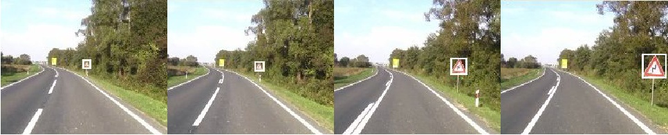
The traffic sign dataset TS2010a
This is a refined version of our earlier TS2010 dataset. The dataset contains images of Croatian traffic signs acquired along Croatian local countryside and urban roads. The images are acquired by a progressive scan sensor and are 720 by 576 pixels wide. They are annotated with image-wide labels as well as with object-level labels and bounding box locations.
License and citing
The datasets may be freely used for academic purposes. If you find our datasets useful in your research, please cite the following paper:
Valentina Zadrija, Josip Krapac, Jakob Verbeek and Siniša Šegvić. Patch-level Spatial Layout for Classification and Weakly Supervised Localization. GCPR 2015 (PDF).
Download
The dataset can be downloaded from the following link. Please unpack the archive and follow the instructions below.
Image files
The image files are located in the directory images.
The file names have the form NNNNN.png,
where NNNNN denotes the five digit number
corresponding to the unique image id.
Images are annotated with image-wide labels as well as with object-level labels and locations. We have used image-wide labels for training classification models and weakly supervised localization models, as well as for evaluating classification models. We have used object labels and locations for trainings and evaluating strongly supervised localization models as well as for evaluating weakly supervised localization models.
Labelling convention
Each annotation is labeled at two different levels of abstraction:
- Level 0: the shape class of the traffic sign (e.g. upright triangle with red border upright, octagon, circle with red border, square, rhombus...).
- Level 1: the traffic sign class (e.g. stop sign, traffic crossing sign, speed limit 60 sign...).
The mapping between the labels and the traffic signs codes
defined by the Vienna convention is provided in the file
signs_map.txt.
The format of that file is as follows:
VIENNA_LABEL LEVEL_1_LABEL LEVEL_0_LABEL
Image-wide labels
Image-wide labels are provided in the files
image_labels_level_0.txt and
image_labels_level_1.txt.
The format of both files is as follows:
IMAGE_ID SPLIT_ID CLASS_ID*
The meaning of the column identifiers is as follows:
- IMAGE_ID: denotes the image with the filename: images/IMAGE_ID.bmp
- SPLIT_ID: denotes the train/test split (0 for test, 1 for train)
- CLASS_ID*: comma separated list of object classes present in the image.
Object labels
Object labels are provided in the files
object_labels_level_0.txt and
object_labels_level_1.txt.
The format of both files is as follows:
IMAGE_ID CLASS_ID X, Y, H, W
The meaning of the column identifiers is as follows:
- IMAGE_ID: denotes the image with the filename: images/IMAGE_ID.bmp
- CLASS_ID: the object class
- X,Y: upper left corner of the object's bounding box
- H,W: the height and the width of the object's bounding box
Track information
Most physical traffic sign are visible in multiple images (4 on average).
Thus, a simple subdivision of the dataset
would likely produce unrepresentative result
due to employing the same physical traffic sign
for training and evaluation.
In order to make it possible to avoid this undesired situation,
we provide the file groups.txt.
Each line of that file denotes a disjoint group to which
the traffic signs from the corresponding lines of other files belong.
If you subdivide the dataset in a way that
all images from each group remain together,
all physical signs shall be represented in exactly one fold.