
Introduction
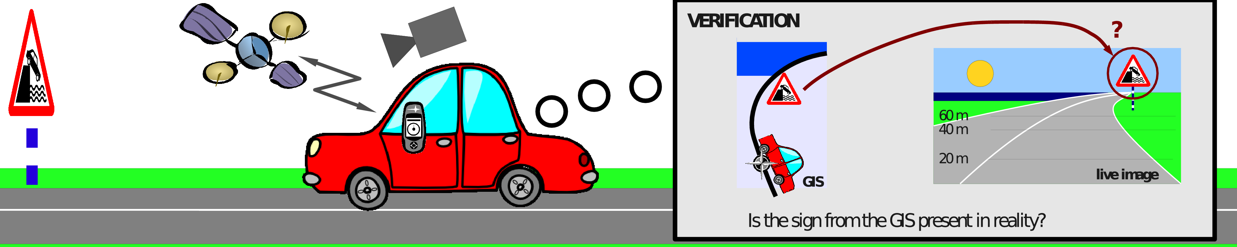
This project was concerned with exploitation and maintenance of geoinformation inventories for storing elements of traffic infrastructure. The main motivation for developing such systems is to provide a direct and comprehensive insight into the prescribed state of the road. This capability is subsequently applied for streamlining various kinds of safety inspections of a public road network in operation. The most important objective of road safety inspection concerns assessing the compliance of traffic control infrastructure. The inspections are designed to detect anomalies such as broken, covered, worn-out or stolen traffic signs, and erased or incorrectly painted road surface markings. In current practice, this task is carried out by expensive and subjective experts, who perform visual comparison of recent georeferenced video against the reference state stored in the geoinformation inventory.
Research objectives
The main goal of this project is to streamline the procedures which form the basis for road safety inspection. We attempted to achieve this goal by researching ways to relax the dependencies on trained human experts. In particular we wished to find out whether reliable detection and recognition of different kinds of traffic signs and surface markings could be performed automatically by computer vision techniques. It is fairly obvious that such facility would lower the costs of assessing the roads for which there already exist corresponding geoinformation inventories. However, we also note that this functionality would considerably simplify the mapping of new roads by creating new geoinformation inventories from acquired georeferenced video.
The achieved results
The answers to our questions turned out to be mostly positive. Most of our work concerned triangular warning traffic signs, as the most frequent sign superclass along the Croatian local roads. We have shown that a performance of 100% recall (all warning signs correctly detected) with near 100% precision (very few false positive detections) and almost 100% correct recognition recognition rate is feasible. Other experiments suggest that similar results could be obtained on other kinds of ideogram-based traffic signs as soon as appropriate numbers of respective training samples are collected. Finally, we have also achieved fair detection and recognition rates of coloured direction tables.
Research on road surface markings also produced encouraging results. We have demonstrated fair results in detecting and recognizing centerlines, zebras, and cross-hatched islands. We have also presented an opportunity to create comprehensive orthogonal mosaics of road appearance.
For detailed results, please have a look at results and publications.
Partners
- Croatian science foundation
- Institute of transport and communications, Zagreb, Croatia
- Faculty of electrical engineering and computing, Zagreb, Croatia (ZEMRIS)
- Technical University Graz, (EMT, Axel Pinz)
Funding
The project has been jointly supported by the National foundation for science, Institute of transport and communications and TU Graz.